| Date | November 2012 | Marks available | 10 | Reference code | 12N.2.bp.3 |
| Level | SL and HL | Paper | 2 | Time zone | |
| Command term | Examine | Question number | 3 | Adapted from | N/A |
Question
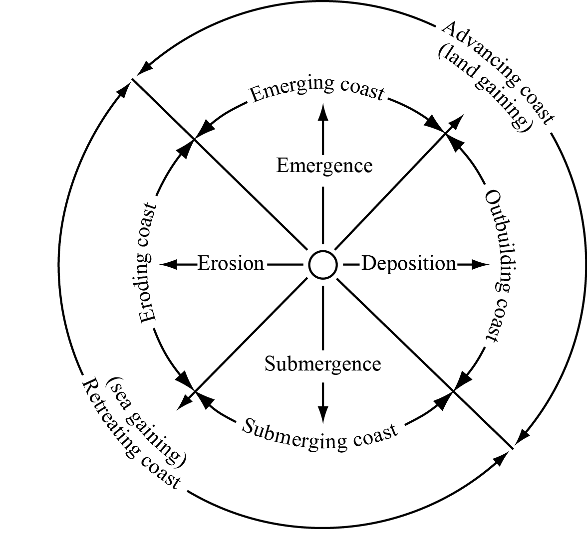
The diagram shows a model of coastal advance and retreat.

[Source: http://science.jrank.org/article_images/science.jrank.org/coasts-and-coastal-processes.1.jpg]
Identify two reasons shown on the diagram why some coasts advance.
Explain why cliffs are often found along retreating coasts.
Explain the global distribution of ocean ridges.
Examine how the exploitation of one named oceanic resource has led to geopolitical conflict.
Markscheme
Emergence / an emerging coast [1 mark].
Deposition / an outbuilding coast [1 mark].
Sea is gaining/eroding the land to cause a cliff [1 mark]. Award further marks for an explanation of two or more processes, or an explanation of the cyclical nature of cliff erosion (wave-cut notch and subsequent collapse). Another approach may be to argue that a sea-level rise exposes new parts of the coastline to erosion/undercutting. There may be alternative explanations.
Ridges are a linear belt of submarine mountains / or other definitional statement [1 mark]. They occur at spreading (divergent) plate boundaries [1 mark] where convection currents in the mantle cause the plates to diverge thus allowing magma to rise [1 mark]. The mid-ocean position should be clear [1 mark] and additional marks should be awarded for use of examples.
Other valid developments (including those using a diagram) can be awarded marks in substitution for those identified above.
The question does not specify a particular resource, so candidates may examine fish, oil or other mineral resources. There should be some identification of the countries involved, the resource, the dispute and the nature of the conflict.
To reach band E and above, candidates are expected to have used one or more detailed, named examples. Potential examples include: Canada, Denmark, Norway, Russia and USA over Arctic oil and gas; South Korea and Japan over the East Sea/Sea of Japan (either oil or fishing).
Marks should be allocated according to the markbands.
Examiners report
Some responses explained the cycle of cliff formation well – focusing on wave action, undercutting and falling away of sections of the coastline.
This question was either understood and done well or completely misunderstood. Some recognized the location mid-ocean and on the plate margins but most were unable to locate ocean ridges and many thought they were on the edge of continents.
“Geopolitical” was not understood by many. A description was given on the perils of overfishing, for example. Those who made specific reference to a named resource, for example, oil or fish, were able to place it in context to a conflict, with some clear identifications of the problem and why/how the conflict is occurring.

