| Date | November 2013 | Marks available | 6 | Reference code | 13N.2.hl.7 |
| Level | HL only | Paper | 2 | Time zone | |
| Command term | Explain | Question number | 7 | Adapted from | N/A |
Question
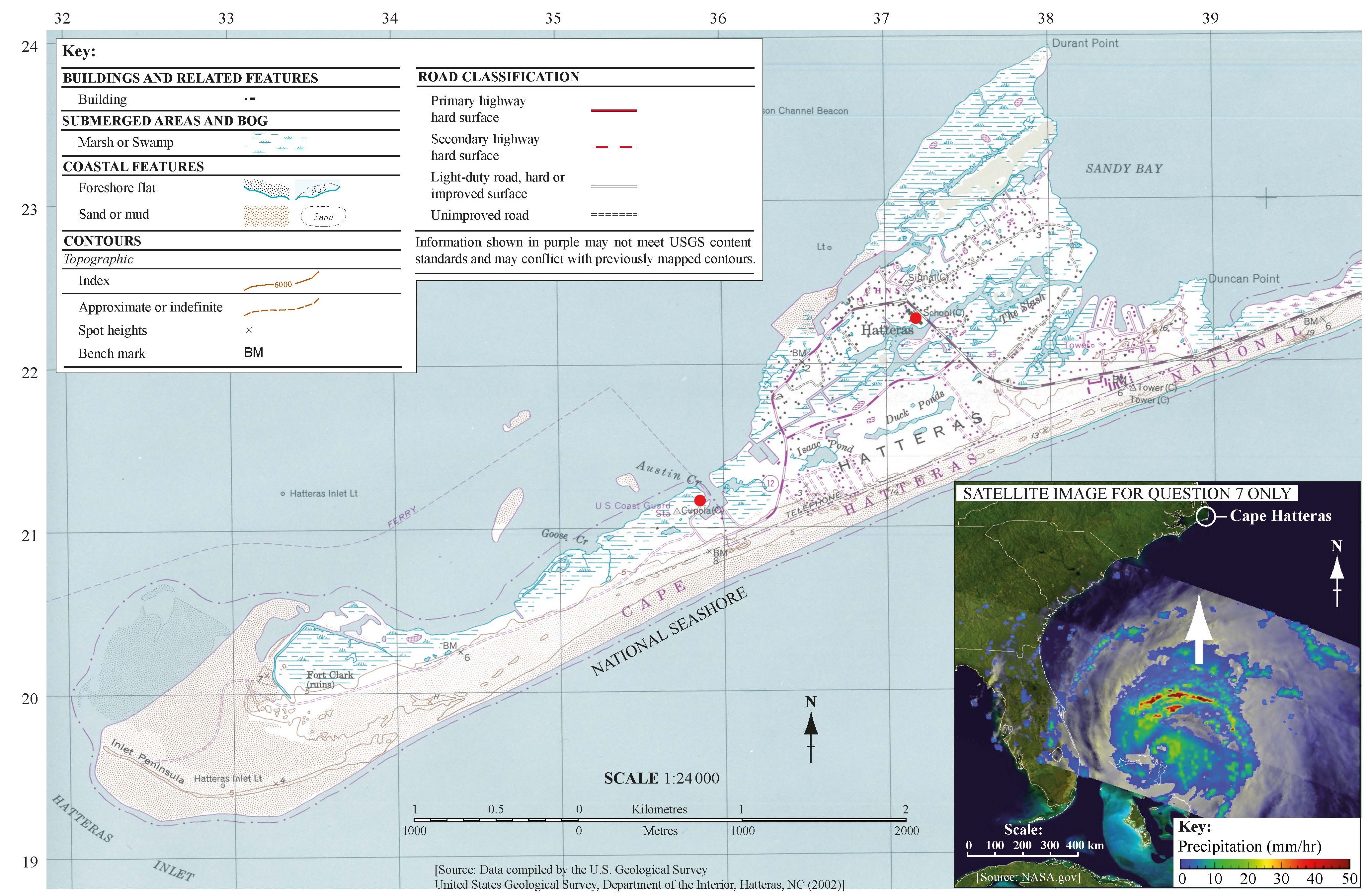
The map shows the Cape Hatteras area of the east coast of the USA. The satellite image shows Hurricane Irene (2011), a few days before it reached Cape Hatteras.
(i) State the height in metres of the highest point west of gridline 35.
(ii) State the four-figure grid reference for the square in which this point is located.
(iii) State the shortest distance by road, in kilometres, between the school and the ferry at Cupola.
Using map evidence only, explain why the inhabitants of this area were particularly vulnerable to the impacts of Hurricane Irene.
“The level of economic development is not the main factor affecting the impact of a tectonic hazard event on a community.” Discuss this statement, with reference to either earthquakes or volcanoes.
Markscheme
(i) 11 metres (allow 7 metres)
(ii) 3419 (3320 for height of 7 metres in part (i))
(iii) Award the full [2 marks] to answers in the range 2.6 to 2.8 km.
Award [1 mark] to answers in the range 2.4 to 2.5 km or 2.9 to 3.0 km.
Explanations based on the map include:
- low relief (must state actual heights)
- limited evacuation possibilities by road – one road to the east and possible congestion
- limited evacuation possibilities by sea – only one ferry shown
- presence of a school – particularly vulnerable age group
- lack of protection from the south as hurricane approaches – though coast dunes appear higher than inland areas
- flatness and large areas of marsh increase the flood risk from heavy rainfall and potential flooding on evacuation routes
- exposure to the ocean and flat relief – means little friction therefore very high potential wind speeds
- situated directly in path of the hurricane track (as photograph on map shows).
Award [1 mark] for each explanation based on the map, and another [1 mark] for any further development (as indicated above).
The full [6 marks] can be awarded for six explanations without further development, or three explanations with development, or any combination thereof.
Answers should refer to examples of only one tectonic hazard type (earthquakes or volcanoes). Discussions should balance hazard events where the level of economic development proved to be a main factor affecting the impact, with other hazard events where this is not the case. In addition to economic development, factors such as population density, intensity of the hazard, time of day, awareness, prediction and warnings, ability to evacuate, preparedness, landscape, geology, and proximity to the hazard source could be taken into account. It is acceptable to argue that many/some of these may relate indirectly to levels of economic development.
If the response only looks at the factor of economic development it should not be credited above band D.
At band E candidates should provide some balance between economic and other factors and begin to show some attempt at evaluation.
At band F there should be a well balanced evaluation/conclusion.
Marks should be allocated according to the markbands.

