| Date | May 2012 | Marks available | 10 | Reference code | 12M.2.bp.13 |
| Level | SL and HL | Paper | 2 | Time zone | |
| Command term | Examine | Question number | 13 | Adapted from | N/A |
Question
The false-colour satellite images compare the Pearl River Delta in southern China in 1979 and 2003.

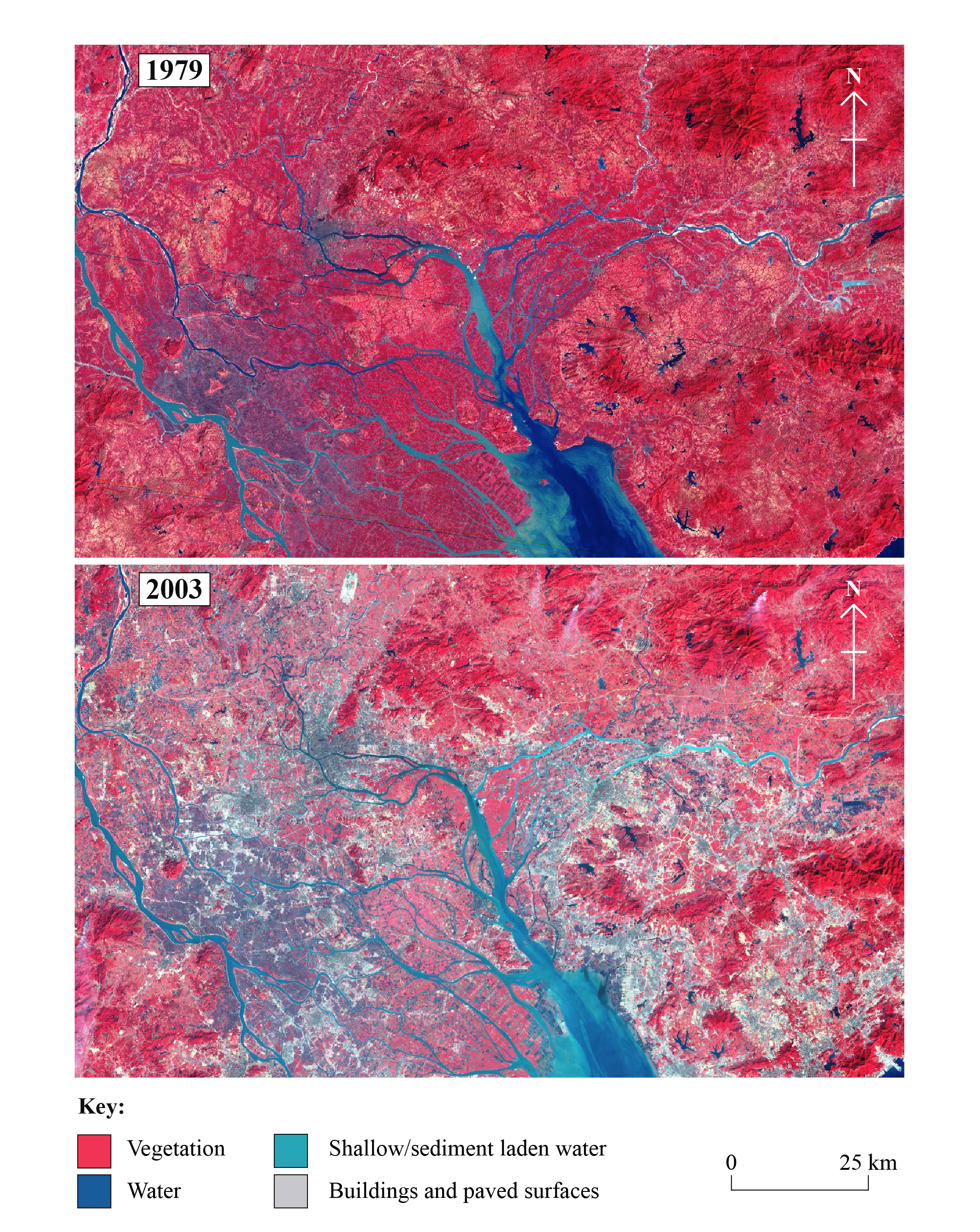
[Source: First image: Jesse Allen, 1979, Landsat 3 MSS, pearlriver_l3_1979292, GLCF, Maryland, 2012; Second image: Jesse Allen, 2003, Landsat 7 ETM+, pearlriver_l7_2003010, GLCF, Maryland, 2012]
Describe the pattern of urban growth since 1979.
Suggest three reasons for the rapid growth of some cities.
Examine the factors that determine the socio-economic characteristics and location of residential areas within cities.
Markscheme
There is a significantly more urbanized area in 2003 compared to 1979.
In 1979 the main urban area was close to the river and since then has grown into the floodplain. In 2003 the floodplain/lower land has been occupied by urban development. The urban area now extends further north and has increased significantly in the eastern part of the region shown. The urban development is more dense in 2003 as shown by the change in colour. More urban roads/communication are evident in 2003. Award 1 mark for each valid point to a maximum of 4 marks.
Suggestions might include rural-urban migration, development of industry/economic development, increased employment opportunities, government policies, increased quality of life in urban areas, improved communication links, increased mechanization and loss of employment in rural areas, natural population increase. Three distinct, developed suggestions should be provided for up to 2 marks each.
Socio-economic characteristics include demographic, political, social and economic factors, but it is not necessary for candidates to consider all of these in equal depth.
The factors affecting the socio-economic characteristics and location of residential areas include: history (age, quality of buildings); physical geography (geology, drainage, and relief may mean that higher class buildings are built in less hazardous locations); accessibility and transport links; the location of industrial and commercial areas; wealth, ethnicity and family status; the relative importance of urban processes such as suburbanization, urban sprawl, counter-urbanization, gentrification and rural-urban migration; as well as natural population increase. This is not a complete list, and other factors may be equally important, depending on the city or cities in question.
The location of residential areas within a city may be different in economically poor countries than in richer countries. For example (numerous exceptions aside), the central areas of rich cities may have poor quality housing (inner-city slums), whereas the poorest residential areas in poor cities often tend to be found on the city fringe (shanty towns).
Maps or diagrams may substitute for text.
To reach markbands E/F, candidates should examine a range of factors, and offer sufficient depth by way of data, maps, examples or case studies to demonstrate a sound understanding of the topic. It is not necessary for candidates to examine all of the factors mentioned in order to obtain full marks.
Marks should be allocated according to the markbands.
Examiners report
Few responses were convincing, but most scored some marks.
There were some solid answers to this question.
Many candidates found it difficult to structure their responses to this question, with weaker ones incorporating urban models that added relatively little of value to their response. There was more development of the location of residential areas by most candidates than of the areas' socio-economic characteristics.