| Date | May 2012 | Marks available | 10 | Reference code | 12M.2.bp.2 |
| Level | SL and HL | Paper | 2 | Time zone | |
| Command term | Discuss | Question number | 2 | Adapted from | N/A |
Question
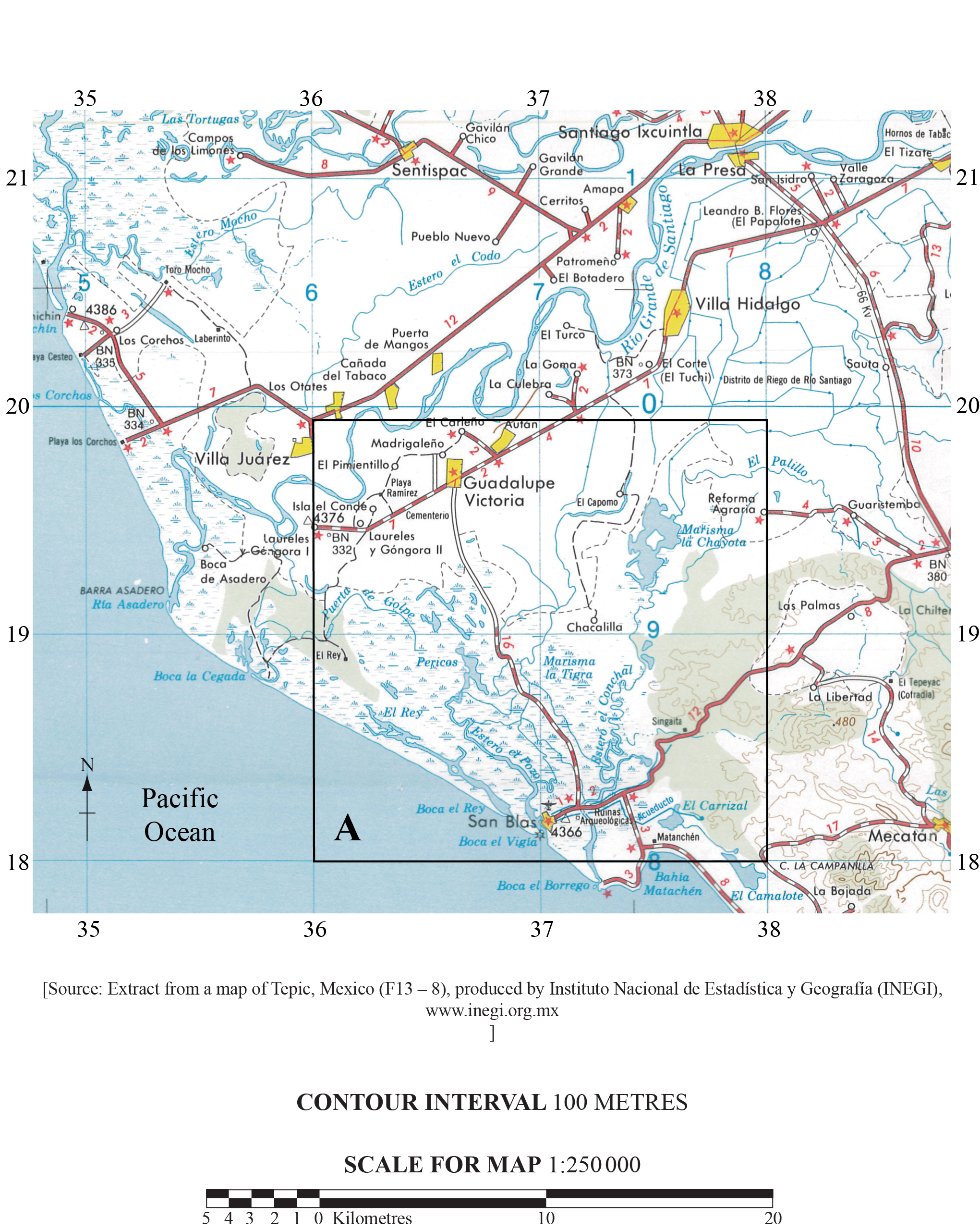
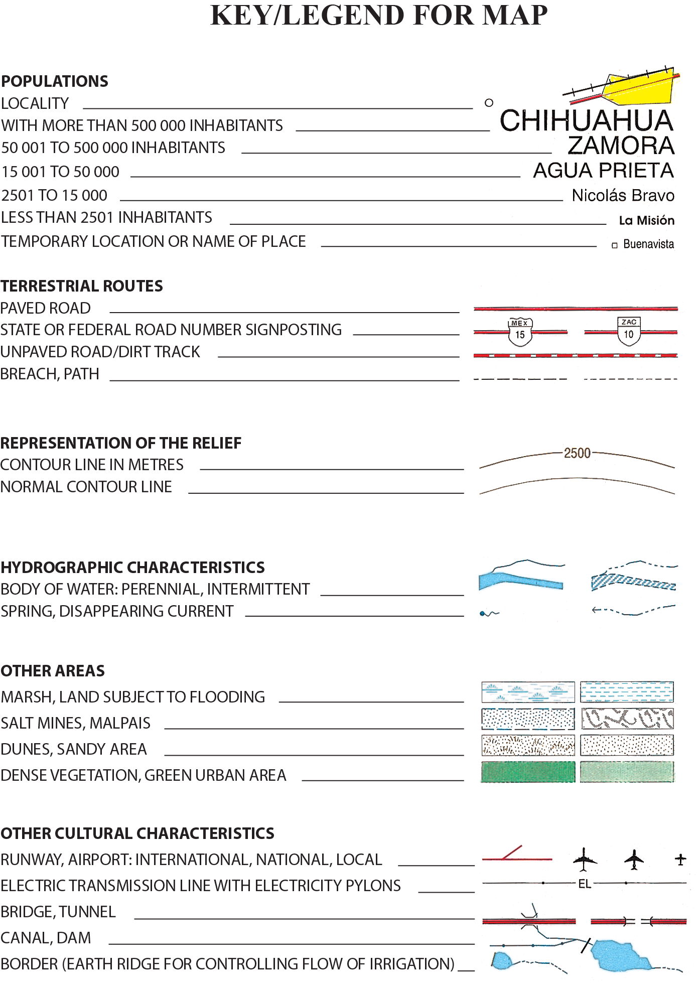
The map extract shows an area in western Mexico. The scale of the map is 1:250 000 and the contour interval is 100 metres.

Describe the geographical characteristics of the Río Grande de Santiago downstream from La Presa.
Analyse how the freshwater resources shown in box A on the map could be used for different purposes.
“People should not try to prevent rivers from flooding.” Discuss this statement.
Markscheme
Award 1 mark for meandering, 1 mark for south-west direction and 2 marks for other characteristics such as oxbow lake or delta.
Award a maximum 3 marks for a list of landforms with no overview/description.
Full marks should not be awarded in the absence of map evidence – names or grid references.
Use of the river for irrigation, navigation, domestic use.
Wetland has potential for tourism, nature reserves, farming, aquaculture.
Lakes – fish farming, tourism, sport and recreation.
At least two different types of water resource (wetlands, rivers, lakes) should be analysed.
A maximum of 4 marks should be awarded where only one resource is analysed.
Full marks should not be awarded without some use of map evidence – names or grid references.
There are various approaches to answering this question. Candidates could focus on avoiding the expensive consequences of river flooding, or the impacts of levée building on floodplains or alternative stream management strategies.
Answers should propose arguments for and against allowing rivers to flood. Arguments against could include the need to protect population, settlements, infrastructure, farmland crops and livestock from loss.
Mention of drawbacks of natural flooding could include loss of agricultural land, the cost of relocation of population, transport disruption, contamination of water supplies, the spread of disease and disease-carrying insects, loss of life and property. Reference could be made to flood frequency and the cost of protection from small, medium and large floods.
Counter-arguments may refer to engineering strategies that actually exacerbate flooding downstream in terms of the increased volume and reduced arrival time of a flood surge. The benefits of allowing rivers to flood naturally might include reduced costs of levée and dam construction, the accumulation of new soil thus raising fertility and reducing the need for chemical fertilizers, more organic content entrained in the river boosting the aquatic ecosystem, lower and later flood crests, and less erosion of the river bed. Answers may also refer to the benefits of the re-establishment of wetland areas to absorb floodwater, thus lowering flood peaks and reducing the risk downstream.
Good answers will probably conclude that a balance of protection in some areas and allowing floods in others is the best solution. Not all of the above is needed for an answer to reach the top bands, however, answers that present only one aspect of the argument should not be credited above band C.
Marks should be allocated according to the markbands.
Examiners report
Descriptions of the "geographical characteristics" were poor and often failed to include direction of flow or to identify specific landforms that were clearly visible on the map.
Many attempts failed to distinguish between the different freshwater resources shown on the relevant area of the map. Some ideas (such as building a hydroelectric power station) revealed a complete lack of appreciation for scale or reality.
There were some strong, well-balanced responses; weaker responses tended to be purely descriptive of past flood events or flood protection strategies.

